


CHICAGO (WLS) — Our coverage of this story has moved. Parts of the Chicago area could see multiple inches of snow accumulate on Sunday evening into Monday morning.
A lake-effect snow band is expected to set up in or around northwest Indiana on Sunday and will continue into the evening hours and Monday morning.
Three rounds of snowfall are expected during the weekend, starting late Saturday.
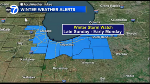
A Winter Storm Watch is in effect for Cook and Will counties from midnight to 6 p.m. Monday, the National Weather Service said.
A Winter Storm Watch is in effect for Indiana’s Lake and Porter counties from midnight to noon Monday, the NWS said.
Watch the latest 7-day outlook from the ABC7 AccuWeather Team.
It is possible that the snow band could impact only parts of northwest Indiana and southwest Michigan, but it could also drift back toward Chicago and northeast Illinois.
ABC7 meteorologists have issued an AccuWeather Alert for Monday, as the possible snowfall could create dangerous travel conditions during the morning commute.
Sunday night into Monday morning, snow could fall at a rate of 2 inches per hour in some areas. Some models show 1-3 inches of snow accumulating, while others show up to 6 inches of snow possible.
Light, on-and-off snow showers could linger through the afternoon hours Monday, said AccuWeather Meteorologist Jaisol Martinez.
But before the lake-effect snow band sets up, scattered snow and rain showers are expected on Saturday night.
Temperatures will take a dip into the 30s on Sunday, with gusty winds up to 35 mph making it feel like it is in the 20s.
No accumulation is expected during the daytime hours on Sunday. Although, there could be some slush on some grassy surfaces, but only if we see some heavier snow showers, said AccuWeather Meteorologist Larry Mowry.
Temperatures will drop into the 20s on Sunday night area wide.


